Hiking
Our cabin is centrally located to the best hiking in Shenandoah National Park and is less than 10 miles from its two most popular hikes — Old Rag Mountain and Whiteoak Canyon. Here are some of our favorite hikes within a short drive of our cabin.
Most of our guests come to the Roost to hike — and for good reason — as we are in the middle of the best hiking in Shenandoah National Park. Each of these hikes is in the Central District of the park and we recommend you carry PATC Map 10 with you if you hike. We have a copy at the cabin. We have also made PDF maps available for download for some of these hikes; print those out or save to your phone.
Hikes on this page
9.1 miles
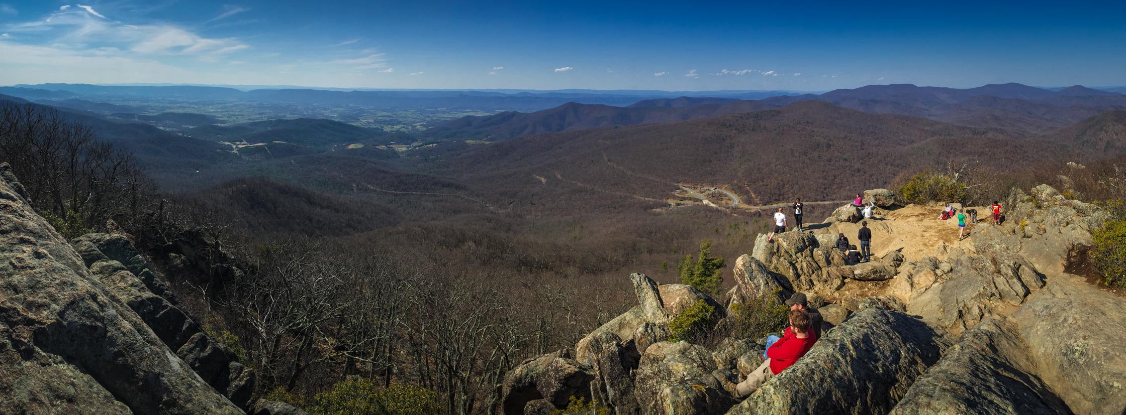
Certainly the most popular hike in Shenandoah National Park, this 9.1 mile loop offers a little bit of everything, including technical rock scrambling, 360° panoramic views from the top, and a leisurely stroll through forests and streams back to your car.
5.8 miles
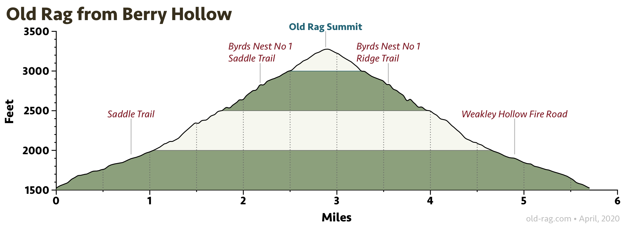
This hike avoids the rock scramble and much of the congestion of the standard Old Rag loop. It is also quite a little bit shorter.
9.7 miles
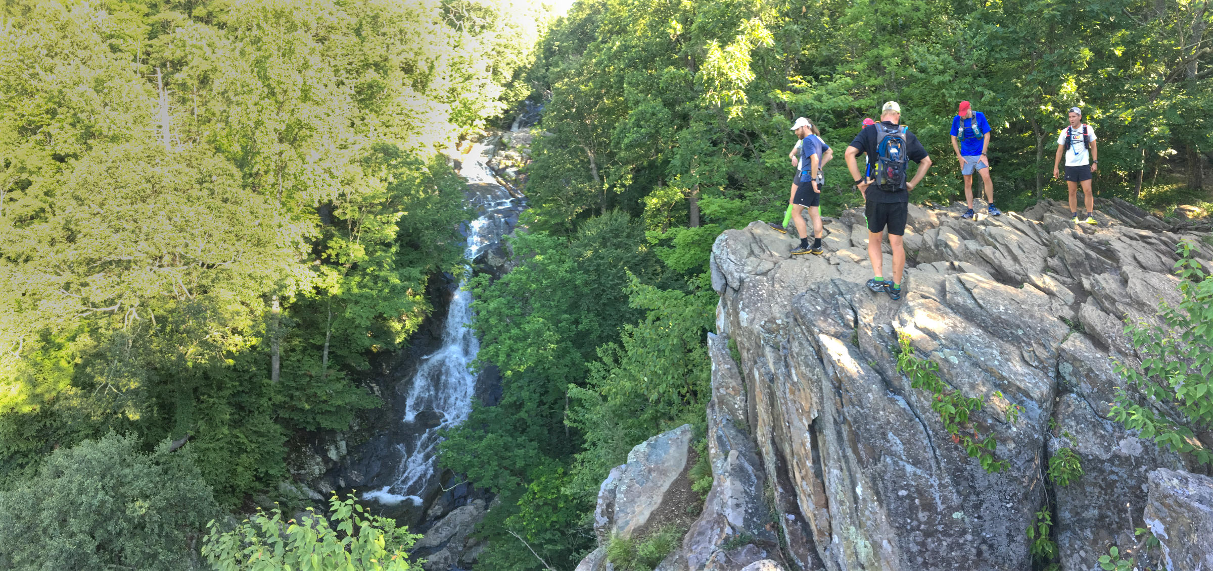
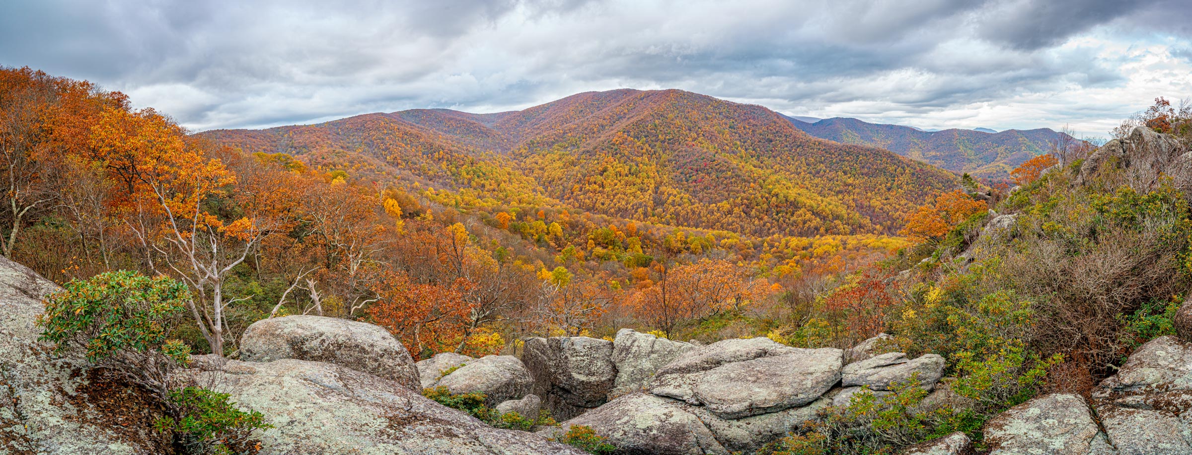
Probably the best loop in Shenandoah National Park for waterfall lovers, the route climbs up Whiteoak Canyon and descends down Cedar Run. Whiteoak Canyon has six waterfalls, with heights from 35 to 86 feet. Cedar Run has even more, albeit smaller, cascades. In the summer, the swimming holes, especially on Cedar Run, are excellent.
10.7 miles
A relatively secluded hike up Nicholson Hollow, passing by the ruins of an old farmhouse.
11.6 miles
A large loop adjacent to Old Rag, passing by the restored Corbin Cabin, and excellent example of the numerous farmsteads that dotted the hillsides and hollows before the establishment of Shenandoah National Park.
6.0 miles
A no-frills loop in a quiet corner of Shenandoah National Park. If you are going back to D.C., this hike could be a convenient excursion, as it is just a couple of miles out of the way on the way home.
8.5 miles
This hike begins at the Hazel River Trailhead and explores a relatively secluded area in Shenandoah National Park. This is another convenient excursion on the way to/from D.C.
9.1 miles
This hike climbs the steep Buck Ridge Trail and descends the Buck Hollow Trail, with an extension up to Mary’s Rock. Mary’s Rock is the eighth highest peak in Shenandoah National Park, with panoramic views to the north and west. There are also other, shorter, routes that Climb Mary’s Rock.
8.2 miles
This hike has it all — a pristine mountain stream, waterfalls, well-preserved mountain history, and spectacular view of Virginia wilderness at the top.
Old Rag Mountain hike
- Distance
- 9.1 miles
- Ascent / descent
- 2,400 feet
- GPX file
- Download
- Printable map
- Download PDF
- Driving distance
- 6.2 miles
- Driving time
- 15 minutes
- Driving directions
- Location of trailhead
- Summary
- Certainly the most popular hike in Shenandoah National Park, this 9.1 mile loop offers a little bit of everything, including technical rock scrambling, 360° panoramic views from the top, and a leisurely stroll through forests and streams back to your car.
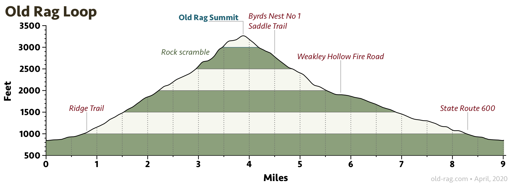
You must have an advanced pass to hike Old Rag. From March 1 – November 30, 2022, visitors to Old Rag Mountain must obtain an Old Rag day-use ticket in advance, in addition to a Park entrance pass.
On nice weekends Old Rag is very crowded, so get an early start or hike it on a weekday if you can. Dogs are prohibited on Old Rag.
Driving directions
It’s a series of lefts to get to the trailhead. From Etlan Road, take a left on Emmett Road, a left on Champe Plain Road and, finally, a left on Nethers Road.
More information
More information on hiking Old Rag on the Shenandoah National Park website, Hiking Upward, AllTrails, REI Hiking Project, and Wikipedia.
Old Rag from Berry Hollow hike
- Distance
- 5.8 miles
- Ascent / descent
- 1,800 feet
- GPX file
- Download
- Printable map
- Download PDF
- Driving distance
- 9.0 miles
- Driving time
- 27 minutes
- Driving directions
- Location of trailhead
- Summary
- This hike avoids the rock scramble and much of the congestion of the standard Old Rag loop. It is also quite a little bit shorter.
Hiking directions
Starting from the trailhead, the hike climbs Berry Hollow Fire Road for 0.8 miles to the four-way intersection with the Old Rag Saddle Trail, the Old Rag Fire Road, and the Weakley Hollow Fire Road. Take a right on the Old Rag Saddle Trail and follow it 2 miles to the summit of Old Rag. On this section you will likely see many hikers on the standard Old Rag loop returning from the summit. Once you soak in the views, retrace your steps back to your car.
Dogs are prohibited on Old Rag.
Driving directions
To get to the trailhead, take Etlan Road (State Route 643) to Weakly Hollow Road (State Route 600) and take a right. You will follow this road for 4.3 miles until it ends at the Berry Hollow Trailhead. The last mile, past the Whiteoak Canyon Trailhead, is on a steep, narrow road. Most cars can make it but you may choose to start the hike from Whiteoak Canyon Trailhead instead, which will extend it by about 1.8 miles.
Whiteoak Canyon - Hawksbill - Cedar Run hike
- Distance
- 9.7 miles
- Ascent / descent
- 3,000 feet
- GPX file
- Download
- Printable map
- Download PDF
- Driving distance
- 8.0 miles
- Driving time
- 17 minutes
- Driving directions
- Location of trailhead
- Summary
- Probably the best loop in Shenandoah National Park for waterfall lovers, the route climbs up Whiteoak Canyon and descends down Cedar Run. Whiteoak Canyon has six waterfalls, with heights from 35 to 86 feet. Cedar Run has even more, albeit smaller, cascades. In the summer, the swimming holes, especially on Cedar Run, are excellent.
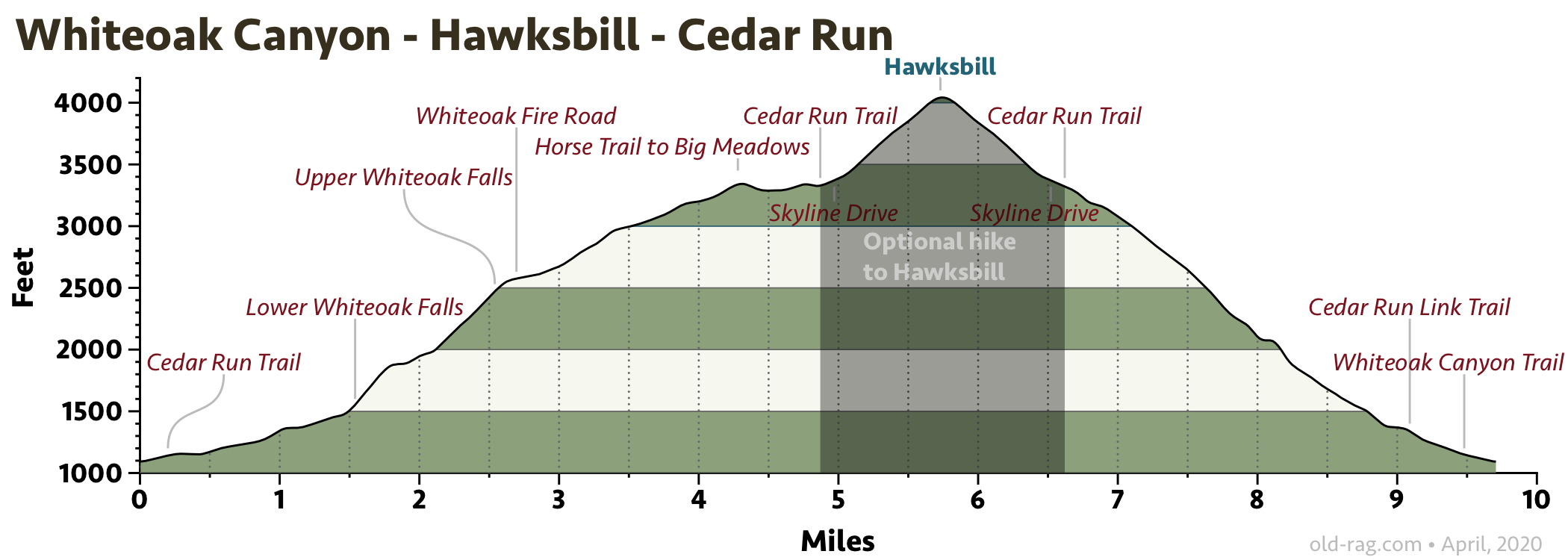
Note: The hike shown here shows an optional short, but vigorous, hike up to Hawksbill (4050 feet), the highest point in Shenandoah National Park with spectacular panoramic views from the top. This out-and-back adds 1.75 miles and 750 feet of ascent. The “normal” hike, described in the links below, is 8 miles with 2300 feet of ascent. Download GPX file for shorter loop .
Driving directions
To get to the trailhead, take Etlan Road (State Route 643) to Weakly Hollow Road (State Route 600) and take a right. You will follow this road for 3.7 miles. The Whiteoak Canyon Trailhead is on your left.
More information
Detailed information, including maps on Hiking Upward. Additional information on AllTrails, and the REI Hiking Project.
Fun fact: The framed Shenandoah National Park poster in our cabin is of one of the waterfalls in Whiteoak Canyon.
Catlett Mountain hike
- Distance
- 10.7 miles
- Ascent / descent
- 2,120 feet
- GPX file
- Download
- Driving distance
- 6.2 miles
- Driving time
- 15 minutes
- Driving directions
- Location of trailhead
- Summary
- A relatively secluded hike up Nicholson Hollow, passing by the ruins of an old farmhouse.
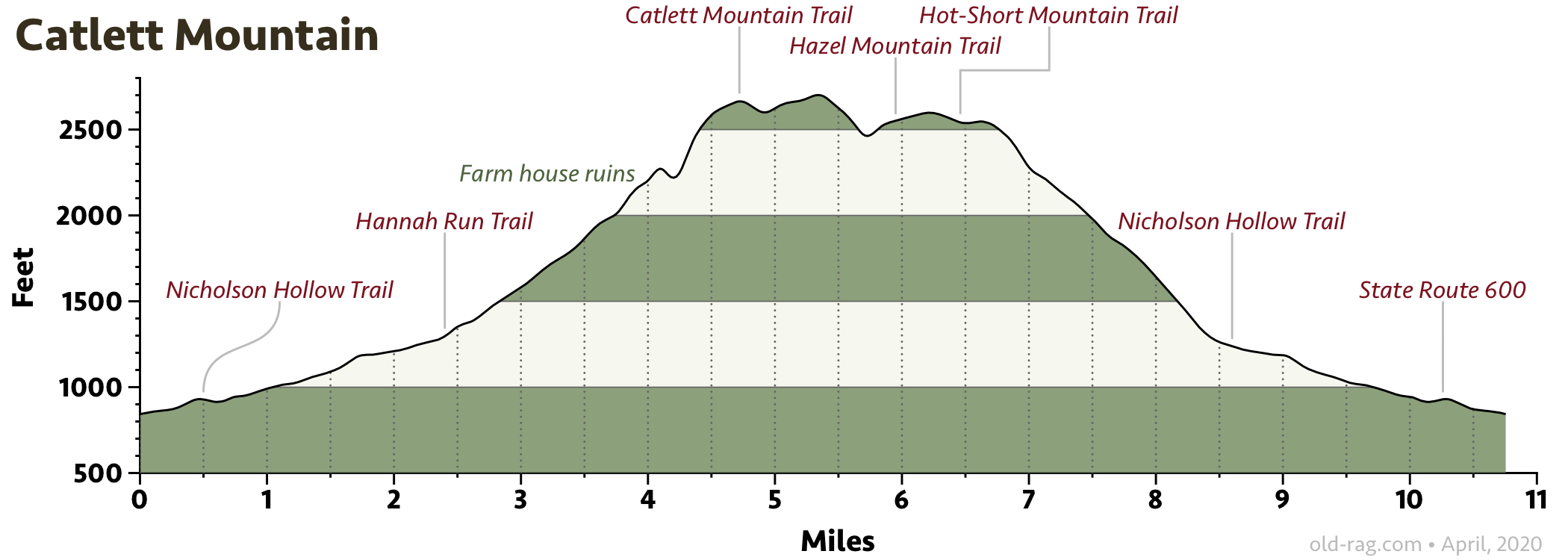
This hike starts from the same trailhead as Old Rag, but avoids the crowds by taking the Nicholson Hollow Trail up a beautiful gorge alongside the Hughes River. After 2.4 miles, the route leaves the river and makes a loop on the Hannah Run, Catlett Mountain, Hazel Mountain, and Hot-Short Mountain trails before returning to the Nicholson Hollow Trail a short distance downstream. Along the way you will pass the ruins of an old farmhouse, one of many that formed a farming community in Nicholson Hollow before the national park was established in 1935. The hike finishes by retracing your steps on the Nicholson Hollow Trail back to your car.
Driving directions
It’s a series of lefts to get to the trailhead. From Etlan Road, take a left on Emmett Road, a left on Champe Plain Road and, finally, a left on Nethers Road.
More information
Detailed information, including maps on Hiking Upward.
Corbin Mountain hike
- Distance
- 11.6 miles
- Ascent / descent
- 2,380 feet
- GPX file
- Download
- Printable map
- Download PDF
- Driving distance
- 6.2 miles
- Driving time
- 15 minutes
- Driving directions
- Location of trailhead
- Summary
- A large loop adjacent to Old Rag, passing by the restored Corbin Cabin, and excellent example of the numerous farmsteads that dotted the hillsides and hollows before the establishment of Shenandoah National Park.
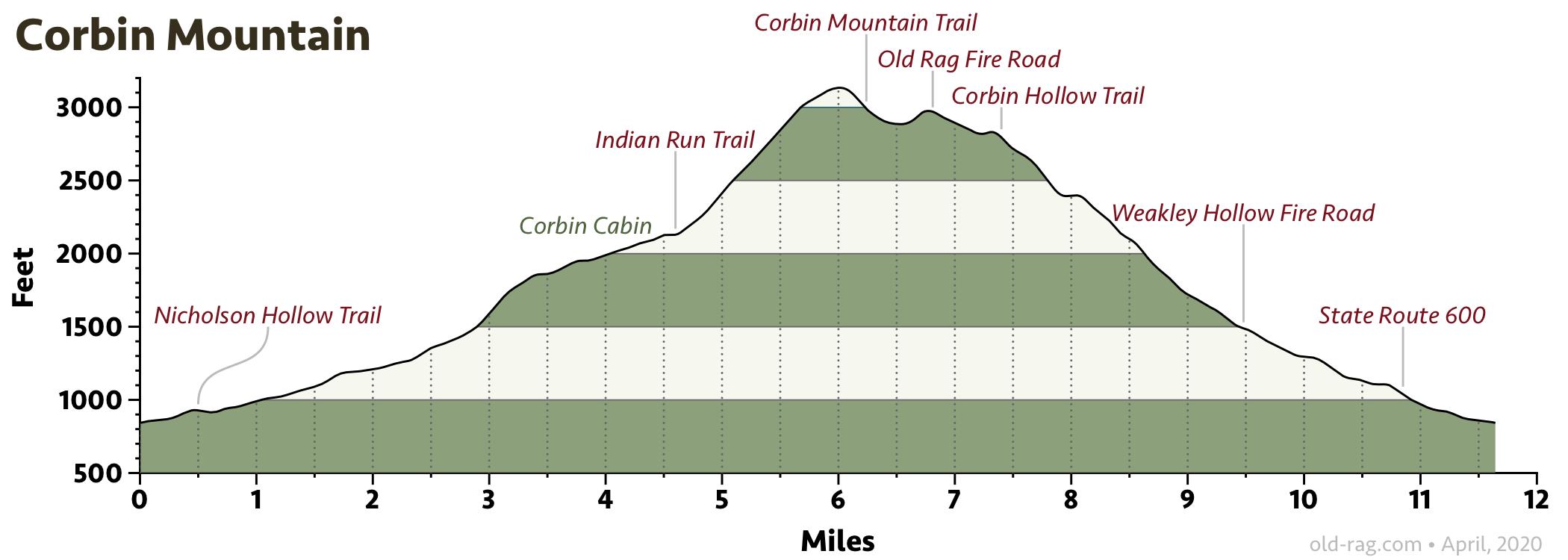
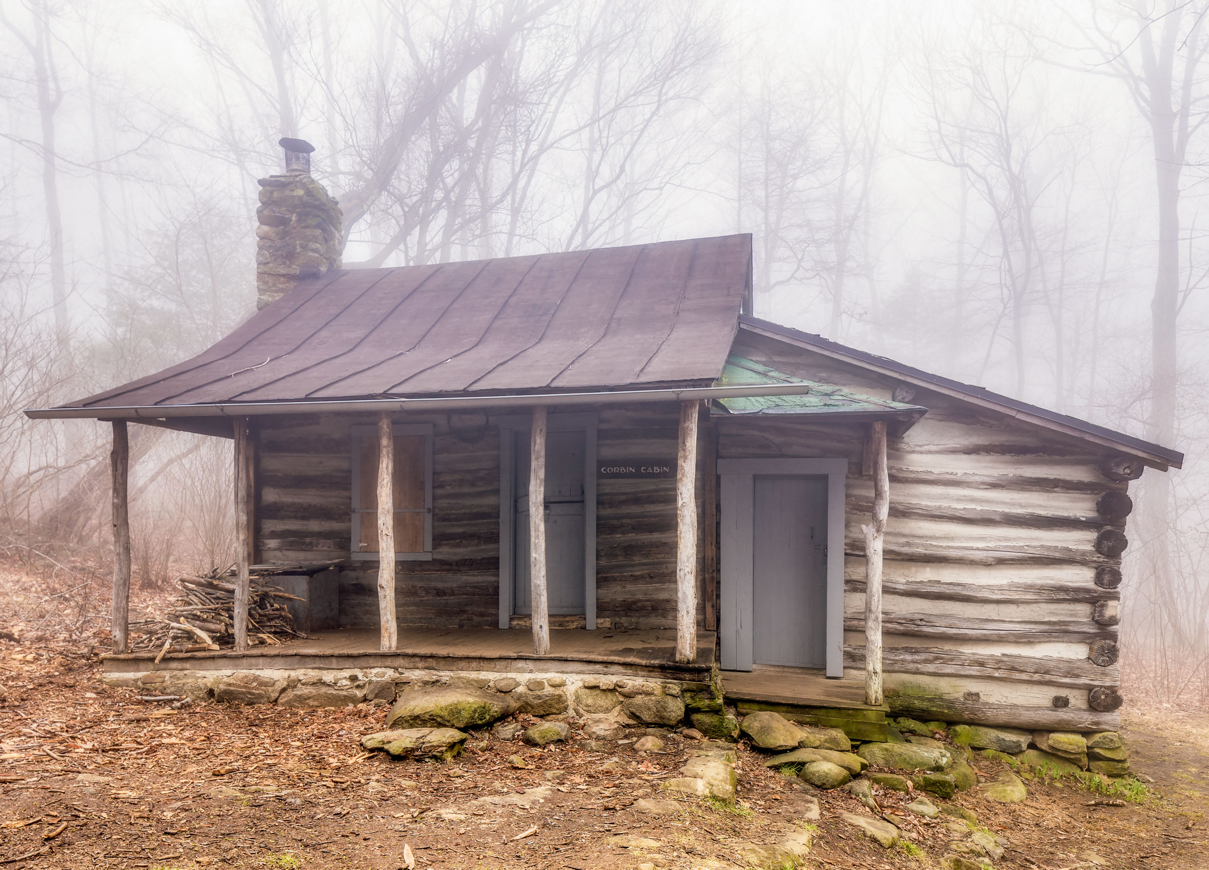
This hike is an 11-mile loop among the old farmsteads of Nicholson Hollow. It begins with a gradual ascent up Nicholson Hollow, paralleling the beautiful Hughes River on the Nicholson Hollow Trail. In 4.4 miles reach Corbin Cabin, the mountain home of moonshiner George Corbin built in 1908. Homes like these were common throughout the hollows of Shenandoah National Park before the residents were forced to leave upon establishment of the park in 1938.
For an easy out-and-back hike, turn back here. Otherwise, take the Indian Run Trail to the Corbin Mountain Trail and then the Old Rag Fire Road. Descend on the fire road a short distance to the Corbin Hollow Trail and take that down to the Weakley Hollow Fire Road, from which it is a 2-mile easy walk back to the car.
Driving directions
It’s a series of lefts to get to the trailhead. From Etlan Road, take a left on Emmett Road, a left on Champe Plain Road and, finally, a left on Nethers Road.
More information
Detailed information, including maps on Hiking Upward.
Stony Mountain hike
- Distance
- 10.5 miles
- Ascent / descent
- 1,950 feet
- GPX file
- Download
- Driving distance
- 8.6 miles
- Driving time
- 18 minutes
- Driving directions
- Location of trailhead
- Summary
- A secluded loop off of the Rose River Fire Road.
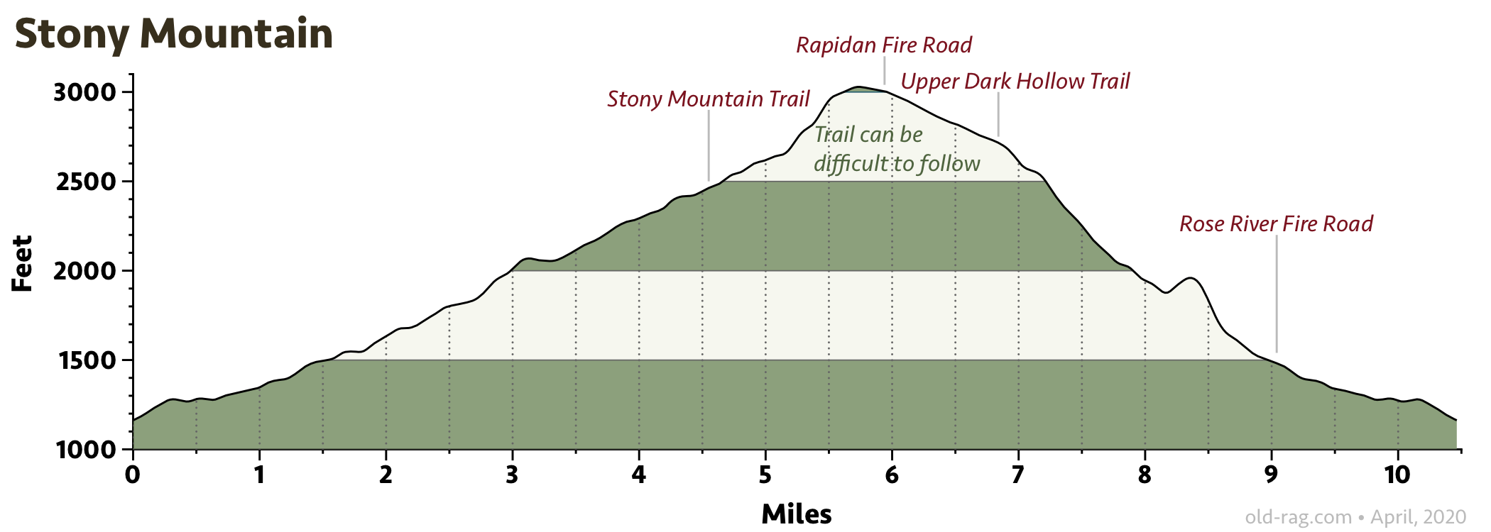
Hiking directions
This hike begins at the Rose River Trailhead and ascends the Rose River Fire Road and then makes a counter-clockwise loop on the Stony Mountain Trail, Rapidan Fire Road, and Upper Dark Hollow Trail before returning to the trailhead on the Rose River Fire Road. The hike is secluded and may not be as well-maintained or more “mainstream” hikes but, if you are looking to avoid the crowds, this might be the hike for you.
Driving directions
To get to the Rose River Trailhead, take Etlan Road (State Route 643) for 4.4 miles to Syria and take a right onto the Old Blue Ridge Turnpike (State Route 670) for 3.1 miles to the Rose River Trailhead.
More information
Detailed information, including maps on Hiking Upward.
Broad Hollow - Pine Hill Gap hike
- Distance
- 6.0 miles
- Ascent / descent
- 1,570 feet
- GPX file
- Download
- Driving distance
- 11.0 miles
- Driving time
- 20 minutes
- Driving directions
- Location of trailhead
- Summary
- A no-frills loop in a quiet corner of Shenandoah National Park. If you are going back to D.C., this hike could be a convenient excursion, as it is just a couple of miles out of the way on the way home.
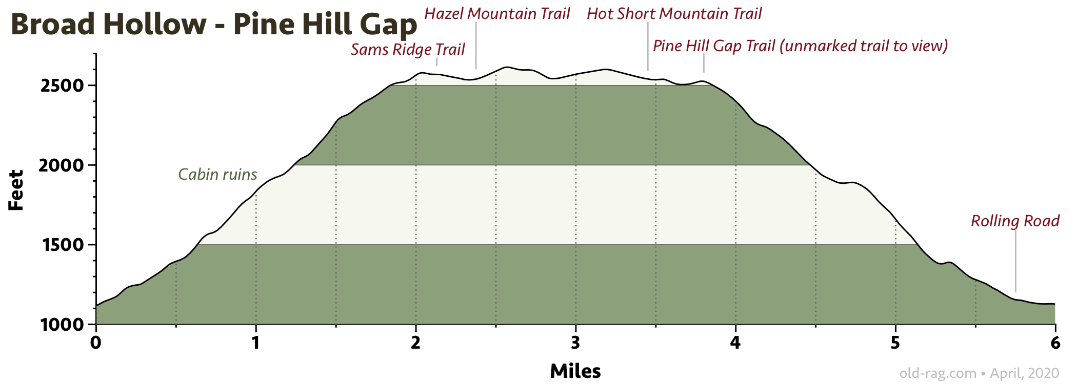
This secluded hike is a no-frills loop in a quiet corner of Shenandoah National Park (the meager trailhead should be a hint). The hike climbs up Broad Hollow, along a lovely creek with a few small cascades, passing by the ruins of an old farmstead cabin.
At the top of Sam’s Ridge and the initial climb, the route turns left onto the Hazel Mountain Trail. At mile 4.3, near an old trail marker for the now-defunct Hot Mountain Trail, is an unmarked trail off to the right that goes out to a rock outcropping and a view.
The hike then descends down the Pine Hill Gap Trail to Rolling Road, at which point it is a short walk back to your car.
If you are going back to D.C., this hike could be a convenient excursion, as it is just a couple of miles out of the way on the way home.
Driving directions
The trailhead is a small pulloff on the side of Rolling Road. From Etlan, take F. T. Valley Road (State Route 231) north for 6.6 miles and then take a left onto Rolling Road and go 2.4 miles.
More information
Detailed information, including maps on Hiking Upward.
Sams Ridge - Catlett Spur hike
- Distance
- 8.5 miles
- Ascent / descent
- 2,300 feet
- GPX file
- Download
- Driving distance
- 10.4 miles
- Driving time
- 19 minutes
- Driving directions
- Location of trailhead
- Summary
- This hike begins at the Hazel River Trailhead and explores a relatively secluded area in Shenandoah National Park. This is another convenient excursion on the way to/from D.C.
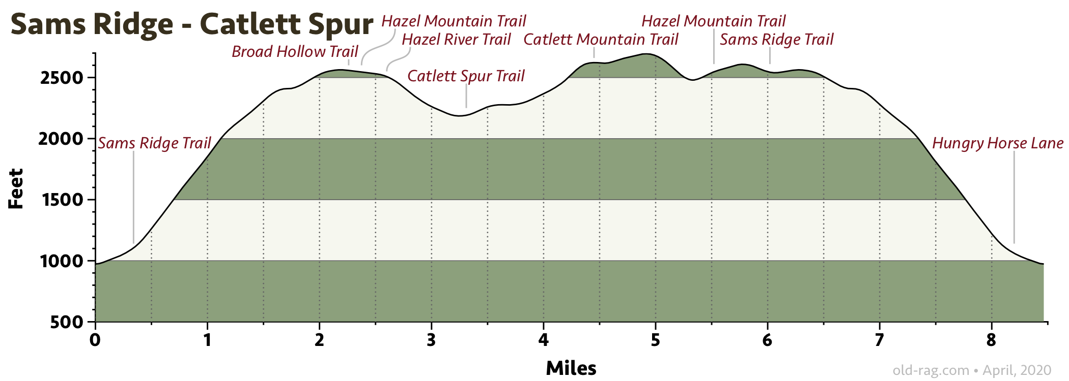
The hike is like a lollipop, with an out-and-back on the Sams Ridge Trail and a loop involving the Broad Hollow, Hazel Mountain, Catlett Spur, and Catlett Mountain Trails. The hike begins up the gated Hungry Horse Lane. The woods are heavily forested and there are no spectacular vistas, meaning there aren’t many views. But if seclusion is what you seek, this might be the hike for you.
If you are going back to D.C., this hike could be a convenient excursion on the way home, as it is just a couple of miles out of the way.
Driving directions
The trailhead is at the end of the gated Hungry Horse Lane. Park on the shoulder of the gravel road (there is room for about six cars).
From Etlan, take F. T. Valley Road (State Route 231) north for 6.6 miles and then take a left onto Rolling Road and go 1.1 miles. Take a right onto Woodward Road and go 0.9 miles to the trailhead.
More information
Detailed information, including maps on Hiking Upward.
Mary’s Rock hike
- Distance
- 9.1 miles
- Ascent / descent
- 2,640 feet
- GPX file
- Download
- Printable map
- Download PDF
- Driving distance
- 15.8 miles
- Driving time
- 23 minutes
- Driving directions
- Location of trailhead
- Summary
- This hike climbs the steep Buck Ridge Trail and descends the Buck Hollow Trail, with an extension up to Mary’s Rock. Mary’s Rock is the eighth highest peak in Shenandoah National Park, with panoramic views to the north and west. There are also other, shorter, routes that Climb Mary’s Rock.
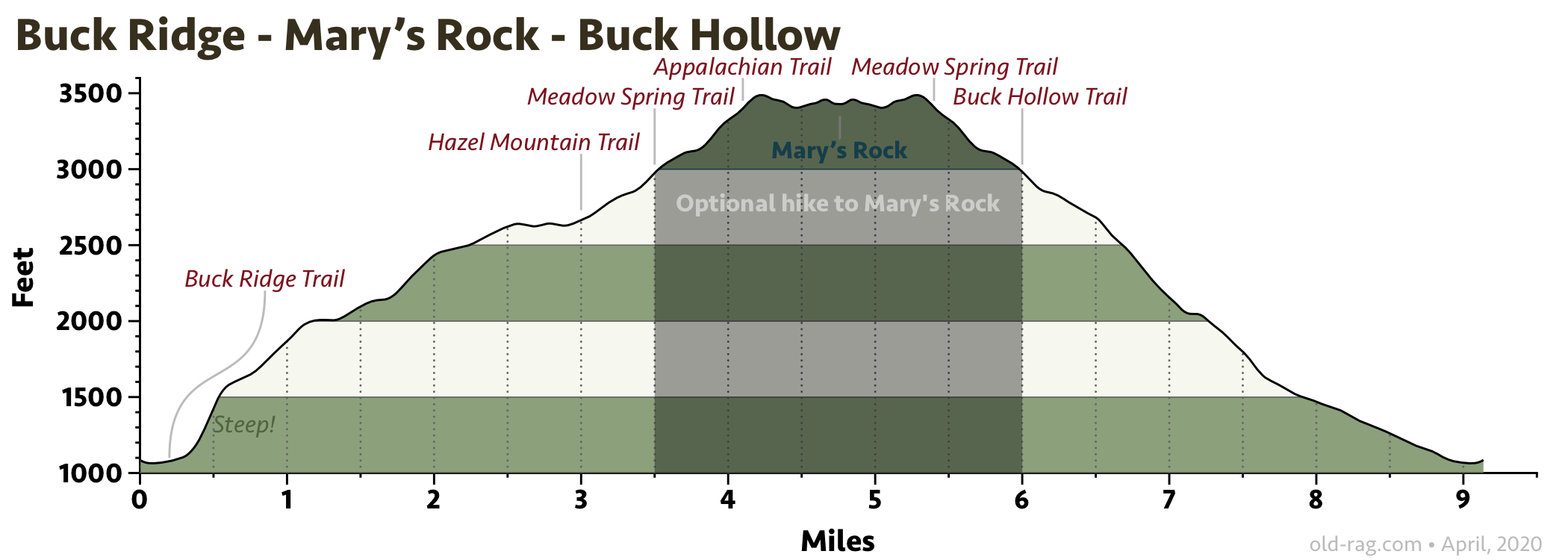
Hiking directions
From the parking area on Route 211 take the Buck Hollow Trail 0.2 miles to the intersection with the Buck Ridge Trail. Take a left onto the blue-blazed Buck Ridge Trail and begin the steep ascent. At the top of the ridge, make a right onto the yellow-blazed Hazel Mountain Trail (mile 3.0) and in 0.5 miles come to the Hazel Mountain parking area on Skyline Drive.
Cross Skyline Drive, and find the Meadow Spring Trail about 50 yards to the left. Climb the Meadow Spring Trail for 0.6 miles, passing the ruins of an old homestead, before meeting the intersection of the white blazed Appalachian Trail (AT). Turn right (north) on the AT following it for 0.8 miles before arriving at the junction of the Mary’s Rock Lookout Trail. Turn left uphill on the Mary’s Rock Lookout Trail for 0.1 miles and come to the Mary’s Rock vista.
To return, retrace your steps back along the AT and down the Meadow Spring Trail to the Hazel Mountain parking area on Skyline Drive. From there, take the blue-blazed Buck Hollow Trail back to your car.
If you are from the D.C. area, this could be a good hike to do on your way to/from the cabin, as it is just a couple of miles out of the way.
Driving directions
The trailhead is a couple of miles west of Sperryville. From Etlan, head north on F. T. Valley Road (State Route 231) to Sperryville and then go west on U.S. 211.
Other variants
Removing the spur to Mary’s Rock makes for a nice (but vigorous) 6.3-mile loop with 1800 feet of ascent/descent. Download the GPX file for that hike. You’ll miss the view from Mary’s Rock, of course, but will enjoy a nice walk in the woods.
If you want to see Mary’s Rock, there are hikes from Skyline Drive that start at Meadow Spring parking area (2.9 miles), Thornton Gap (3.7 miles), or Jewell Hollow Overlook (6.0 miles).
More information
- Detailed information, including maps for the full hike on Hiking Upward.
- Hiking to Mary’s Rock from Thornton Gap (3.7 miles) or the Meadow Spring parking area (2.9 miles) by the National Park Service.
- Hiking to Mary’s Rock from the Meadow Spring parking area (2.9 miles) on The Outbound
- Hiking to Mary’s Rock from the Jewell Hollow Overlook on Skyline Drive (6.0 miles) on virginiatrailguide.com.
Bear Church Rock hike
- Distance
- 8.2 miles
- Ascent / descent
- 2,200 feet
- GPX file
- Download
- Driving distance
- 26.0 miles
- Driving time
- 37 minutes
- Driving directions
- Location of trailhead
- Summary
- This hike has it all — a pristine mountain stream, waterfalls, well-preserved mountain history, and spectacular view of Virginia wilderness at the top.
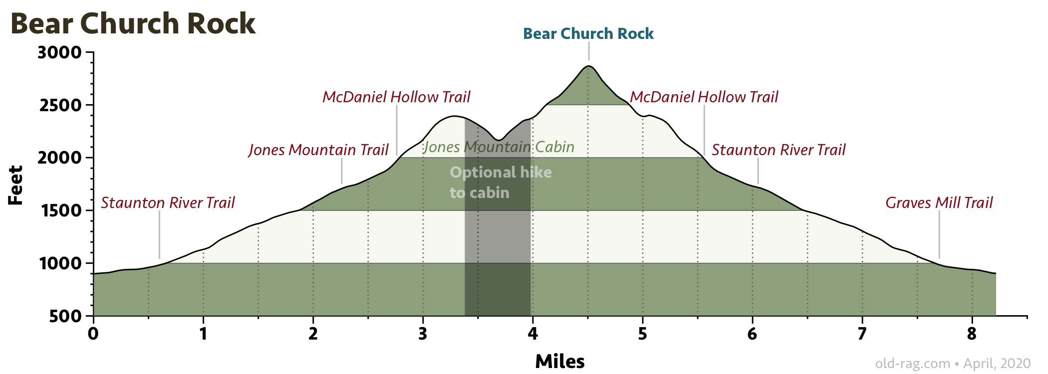
The hike, as shown, includes an optional 0.6-mile out-and-back to Jones Mountain Cabin, a chestnut log cabin built by moonshiner Harvey Nichols in 1918. The cabin is a well-preserved vestige of the types of mountain homes that dotted these mountains before the establishment of the national park in 1935.
Driving directions
The trailhead is north of Graves Mill. From Etlan, take F. T. Valley Road (State Route 231) south for 10.7 miles to Madison. Take U.S. 29 south for 2.2 miles and then take Wolftown Hood Road (State Route 230) west for 3.7 miles to Graves Mill Road (State Route 662). Take Graves Mill Road 6.6 miles to the trailhead.
More information
Detailed information, including maps on Hiking Upward. Additional information on AllTrails, the Virginia Trail Guide, and The Outbound.
Last updated May 6, 2022